Revolutionary theory that challenges the global scientific and hydraulic community
If we control the water in the heights, we control life in all the Peruvian coast. We could even control water floods and double the current agricultural frontier simply by implementing the Nasca Code
It has become an unprecedented theory about the management of the natural water resource at highlands of Andean basins, developing an unprecedented theory about the use of the famous Nasca Lines. Follower of María Reiche's work, author states that the lines represent a giant complex of hydraulic systems that goes beyond religiosity and astronomy.
In his work, the author recounts a very feasible solution about what the ancient Pre-Inca Peruvian inhabitants belonging to the "Nasca Culture", located in the province of Nasca, department of Ica on the most arid and dry coast of Peru, did for delicately handle the liquid element, in a reality of unprecedented climatic changes over 2000 years ago. The author maintains in his work that all this was done with purely hydraulic purposes in order to maintain a subsistence agriculture, without underestimating the cosmic religious affairs of said culture, using only the Andean geography, gravity, inclination of the land and a lot of imagination.
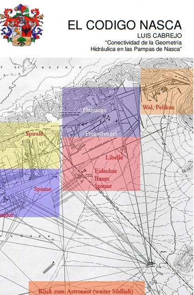
The Nasca Code is a didactic, technological and historical-archaeological genre boot written by Luis H. Cabrejo and first published digitally by the American publisher Lulu Enterprices, Inc. in January 2010 (ISBN 978-612-00-0232-2 having as director of the book the Peruvian anthropologist José Matos Mar) officially registered in the National Library of Peru. Now it can be purchased at www.amazon.com The full title of the work is "El Código Nasca: Conectividad de la Geometría Hidráulica en las Pampas de Nasca". Soon, it will be developing a national dosed irrigation pilot in a valley of a local district of Peru, 100 km south of the city of Lima using Nasca Culture techniques. On Facebook El Código Nasca - The Nasca Code available in English and Spanish.
El Código Nasca es una obra del Género Didáctico, tecnológico e histórico-arqueológico escrito por Luis H. Cabrejo y publicada por primera vez digitalmente por la editorial norteamericana Lulu Enterprices, Inc. en enero de 2010 (ISBN 978-612-00-0232-2 teniendo como director del libro al antropólogo peruano José Matos Mar) registrada oficialmente en la Biblioteca Nacional del Perú. Ahora se le puede adquirir en la empresa www.amazon.com El titulo completo de la obra es "El Código Nasca: Conectividad de la Geometría Hidráulica en las Pampas de Nasca". En 2017 estará desarrollando un Piloto Nacional de Riego Dosificado en el valle del Distrito de Asia, km 100 al sur de la ciudad de Lima usando las técnicas de la Cultura Nasca. En Facebook El Código Nasca - The Nasca Code disponible en Inglés y Castellano.
RELACIONADO / RELATED: INVESTIGACIONES SOBRE LA ESTRATEGIA DE TELECOMUNICACIONES INCAICAS

What mystery is hidden behind the enigmatic Nasca Lines?
For centuries, science has managed to keep the truth hidden, until now. An exciting set of hidden keys, surprising revelations, ingenious riddles, truths, lies, historical realities, myths, symbols, rites, mysteries and assumptions in a plot full of unexpected twists, narrated with an unstoppable rhythm that leads the reader to the secret more jealously guarded from the beginning of our era. The written press does not publish topics that it does not understand, it calls them 'esoteric' issues, specifically when they do not have the capacity or ability to understand.
2010 - Luis H. Cabrejo EL CÓDIGO NASCA
Book Critics
Cecilia Valenzuela, Periodista Journalist Willax National TV "Why not listen, when someone has a really innovative idea. I am pleasantly and impressed by what the author has revealed to us in his work, and we will wait for the authorities that have to do with engineering, culture, the environment, development, agriculture and water in our country, pay close attention to this book"
Federico Kauffman Doig, Arqueólogo Archaeologist "By a simple glance I see that it contains a wealth of refreshing ideas, certainly renewed and that lead to reflect on current issues closely associated with hydraulics and geoglyphs of Nasca"
Carlos Milla Villena, Arqueoastrónomo Astronomer "Luis Cabrejo's proposal deserves admiration and recognition for raising this pre-Inca theory that will make known the advances of our Amerindian wisdom""
Carlos Aylas, Editor El Comercio Newspapers, Washington DC "An excellent educational work and I am sure it will be used as a consultation by the scientific community. It will definitely make a change in Inca history, right now that we are experiencing a period of enormous drought in the country. I hope that the visionaries of politics have that sense of development and progress"
Jose Matos Mar, Antropólogo Anthropologist, Professor San Marcos University Lima "The proposal put forward by Luis H. Cabrejo to organize a National Hydraulic Connectivity Program, based on the experience and knowledge of what the Nasca did to manage and control water, one of the most advanced civilizations of the ancient world, constitutes an important and fundamental contribution for the management of this scarce water resource of all the municipalities and their basins of Peru and, above all, to build a fundamental reform of the agricultural system so that the Peruvians of the poor areas and regions can participate, consider themselves and achieve an economy that strengthens democracy, good governance and the creation of a modern and exporting Peru, in a future panorama of global climate change in the world"
Verónica Ayllon. ATV Channel 9 News [De Película] "Today a new hypothesis is born that arises around the Nasca Lines, where it indicates in his theory that the lines would be, nothing more, nothing less, than an immense hydraulic system of ancestral irrigation"
Anthony Choy. Radio Capital FM Lima Conductor [Viaje a Otra Dimensión] "We must analyze this from another point of view, not everything we do not understand, it has necessarily been done by aliens"
UPDATE 2017 : Italian scientists agree with Peruvians about the true meaning of geoglyphs
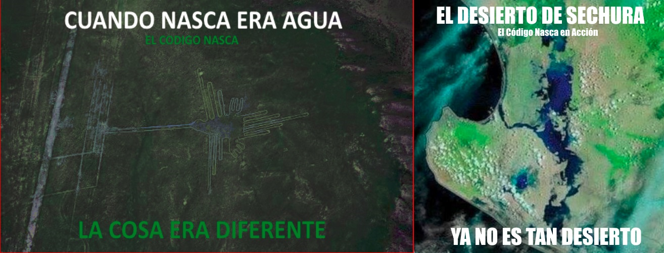
Nasca Lines: The true meaning of geoglyphs is discovered. Interestingly, the spiral structures that exist nearby help explain the reason for their construction. After several years, the motive of the Nasca lines was revealed, but Peruvians had deciphered it more than 10 years ago. These are located in the southern desert region of Peru, the Nasca lines are huge drawings made on the ground. These geoglyphs range from spirals to difficult designs like monkeys, llamas and flowers. These are gigantic, so they can only be seen from an airplane.
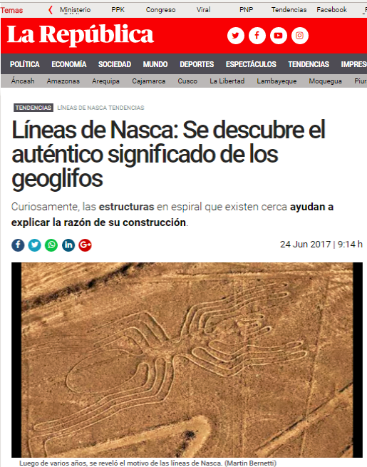
Over the years, many have wondered the reason for its creation, because the Nascas could not enjoy the work in all its splendor. Thanks to the images broadcast by the satellite, scientists believe they have a good hypothesis for the mystery that lines hide. These would be related to water. "They were able to use groundwater for irrigation and aqueducts to benefit their agricultural activity; that is how the Nasca were able to transform the desert into a garden," said researcher at the National Research Council of Rome, Rosa Lasaponara.
After analyzing the images captured by the satellite, Lasaponara observed that there were unusual structures found in the landscape very close to the Nasca lines: spiral-shaped holes called puquios. These photographs allowed researchers to see below the surface and identify some underground water channels that connected these spiral holes. Thus, this revealed that they were part of an advanced and ancient aqueduct system. In this way, groundwater was conducted through the canals to the parts of the region where the Nasca lived and cultivated. The liquid was propelled in part by these spiral puquios, which caused the wind to pass through the underground canals to push the water through the system. Thus, this is a very great discovery, because it would give credibility to a theory that many scientists held on the Nasca lines: they were ceremonial and related to water.
This is because nearby structures were part of a sophisticated liquid system. This makes sense that the ritualistic designs were made to be able to mark the location of the water and / or give thanks to the disposition of that valuable resource. In his work The Nasca Code, the peruvian computer scientist Luis H Cabrejo in 2010 explained the meaning in detail, of how the lines were used for the hydraulic issue for agriculture purposes in the desert.
CASE CLOSED
If we control the water in the heights, we control life in all the Peruvian coast. We could even control water floods and double the current agricultural frontier simply by implementing the Nasca Code
REVISED WITH HYDRAULIC PROFESSIONALS AND WE HAVE AGREED THAT DAMAGED PERUVIAN RECONSTRUCTION MUST BE FOCUSED ON PRIORITY HYDRAULIC MANAGEMENT. IF WE DON'T DO IT, IT WILL HAPPEN AGAIN AND AGAIN. WE WILL ALWAYS FLOODED BY CLIMATE CHANGE. WITHOUT WATER MANAGEMENT SYSTEMS AND EVERYTHING THAT WILL BE DONE WILL BE TEMPORARY BECAUSE IT WILL ALWAYS BE FLOODED IN THE NEXT SEASON BY "EL NIÑO".
"The subject is so simple. Learn from what our ancestors did. The problem is in the INTEGRAL management of the hydraulic issue. Our geography is complicated, and we must adapt to it. The plan of how to do it is looking at the past starting from the heights, containing the flow through high Andean small rock dams and where we will receive early level alerts. In the middle, we have to capture the water, either for platform irrigation and to create artificial / natural lagoons, using the same sloped geography to empower the water. The Nasca did it correctly. Use levels and bring water to low levels, using gravity only. Once you fill the pools, use that water for agriculture throughout the Peruvian coast", Cabrejo said.
We forget about droughts, because we are going to have so much accumulated water that we can lose 20% of agricultural areas in a water season, but we can irrigate an additional 80%, while recovering the lost water flow to the seas. The idea is to use all the tools currently available, using the Nasca technique, delicately handling the hydraulic issue in ways never before seen. Today was a very good day, we understood what they did to manage it. Peruvian Hydraulic Engineers in a multidisciplinary meeting have given me up thumbs in the presentation on the subject of management and reconstruction of the Peruvian Andean hydraulic system. This is how the issue should be handled as the Nasca did milenial ago. PERUVIAN RECONSTRUCTION must be comprehensive, starting on the topic of Hydraulic management.
From the highlands, towards the middle part of the coasts and finally on the low part (coastline) everything must be a comprehensive management system, with early, computerized alerts and information systems for handling in cases of level increases. It is useless to have everything nice and neat on the coastline, if it is going to be flooded and destroyed by "huaicos" and flooded by the rivers. The subject of the climatic phenomenon will become recursive as its now, it will happen again and again, so an extensive territorial rearrangement is needed. People cannot live in the river sides, nor can they make entire cities by the riverbed. Everything is going to get flooded again and again we will lose millions in infrastructure and equipment by reconstructing recursively.
After some years, out of irony of life, paying attention to several anthropologist colleagues and friends, I investigated a possible solution that would fit the world reality, coherent, more immediate, and I found a hypothesis which was originally raised by a group archaeologists , who studied the lines before Dr. Reiche and Kosok, on the use of this complex (Mejía Xesspe 1942, Kroeber Collier 1998, Horkheimer 1947) in which he rightly (without checking it in depth) deduced that the complex had hydraulic purposes

MILLION DOLLAR QUESTION: WHAT ARE THE NASCA LINES?
http://www.facebook.com/
1 - It is a mega Hydraulic Management complex for water and agricultural purposes (Cabrejo)?
2 - It is an astronomical-agricultural calendar (Maria Reiche)
3 - They represented an Andean Zodiac (Paul Kosok)
4 - It is a landing field for aliens (Erich von Däniken)
The coherence of a theory must occur in every conceivable aspect in order to verify its validity. In general terms, the reality of the investigated people, is the same as the current people, it has not changed. The problem continues at levels even higher than those of that time. Currently, water is considered as a resource of primary need at international level and in the future there may be war conflicts over this very important natural resource.
From the great pyramid of CAHUACHI where CAHUAC = TO OBSERVE, SEE, SENTINEL; CAHUACCHI = "PLACE FROM WHERE IT IS OBSERVED"
I compare this feat only, with the wonders of the "Hanging Gardens of Babylon" or with the "Aqueducts of Rome." It is definitely an achievement “Wonder of the World” archaeological style of hydraulic engineering, the basis of many achievements of the Inca Empire. Recall that the Nasca were a Pre-Inca culture, which may have left this technology as the basis of agricultural engineering for our empire based on "Platforms." (Los Andes, or place with Andenes)
"An approximate of 1 million hectares can be reactivated, to realize the magnitude of the figure I tell you that at present we have in production an approximate of 1'800,000 hectares throughout Peru. Unfortunately, of that million hectares on platforms we only have approximately 25% in production, that is, about 250,000 ha, the rest are abandoned and as we always say only the oblivion and the decision of the people who govern can destroy". Mas...
This problem is not a new issue as we will prove in this book that I have called “The Nasca Code”, because I understand that it can be the key to the management of this natural water resource at very delicate levels and with the necessary precision currently required due to the climatic changes that afflict us.
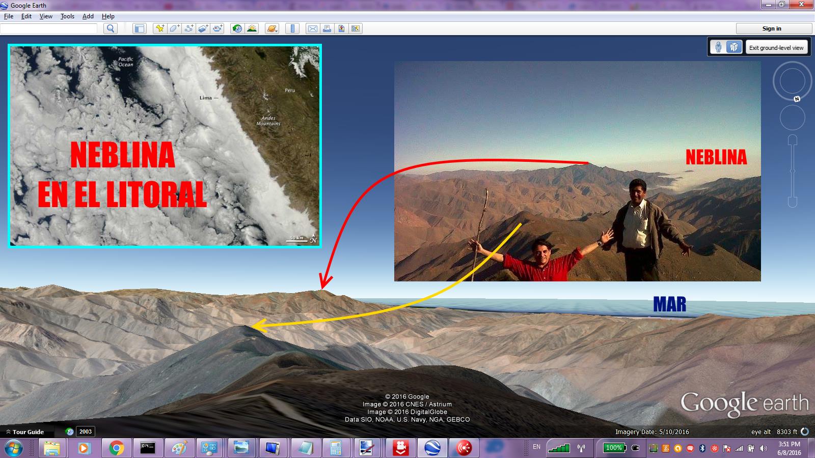
Is it that the Nasca used the mist (atmospheric humidity) to collect all the water transported on the Nasca pampas?
What would happen if we condensed the water from the Peruvian mist and caught it in large accumulators such as Nasca trapezoids and used them to irrigate the entire Peruvian coast? During my last trip to the Caribbean and Central America, I was able to appreciate the climate and topography of all the tropical countries in northern Peru. They have water, Ecuador, Colombia, Venezuela, Panama, Costa Rica, etc. a lot of water, It rains tropically. Great difference when we fly over Peru, especially the coast, is dry, only our inter-Andean valleys and our rivers save us from drought.
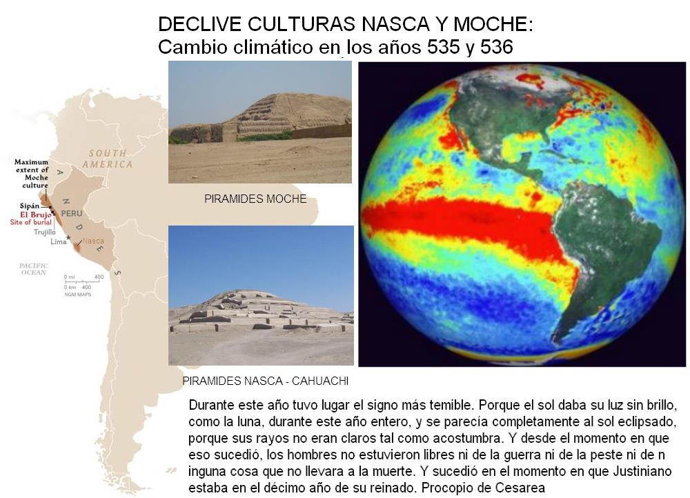
The climatic phenomena of 535-536 were the most serious and prolonged short-term cooling episodes in the northern hemisphere in the last 2000 years. It is thought that this event may have been caused by an extensive veil of atmospheric dust, possibly as a result of a large volcanic eruption in the tropics, or the impact of space debris against the Earth.3 Its effects became widespread, causing weather outside season, bad harvests, and famines throughout the world. Source: http://es.wikipedia.org/
This story is based on a very old civilization, of great hydraulic engineers, who solved problems in the driest and desertest area of the Peruvian coast, which were not allowed to flow until the the water floods finally destroyed it.
OUR HYPOTHESIS
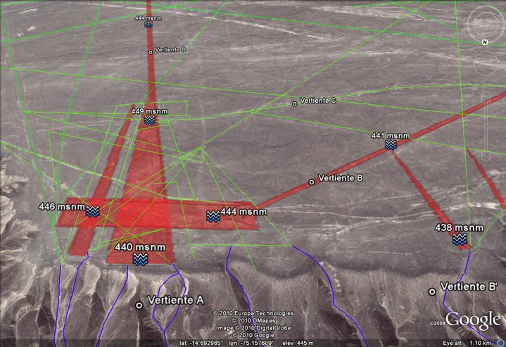
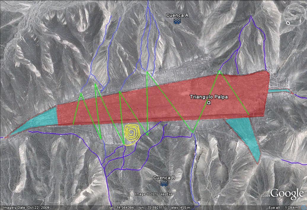
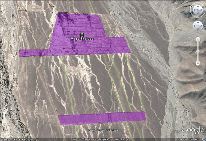
1 - NASCA REMAINED WITHOUT WATER PROBABLE BY MEGA EL NIÑO CLIMATE CHANGE: The strategic location of Cahuachi, to control the affected basin was important. Hence the entire Nasca and Palpa hydraulic network system could have been controlled there. Highligted in red is the area affected mainly by the lack of water. The rivers in blue, stopped producing water affecting the valley completely.
2 - THE WARI (Another neigbor culture) IN THE HEIGHTS OF HUANCAVELICA / AYACUCHO CHANGE THE WATER PATH FOR ITS CROPS AND LOCAL USAGE: We have discovered signs of deviations of rivers to supply water to the villages in the heights of Nasca. They ran out of water gradually.
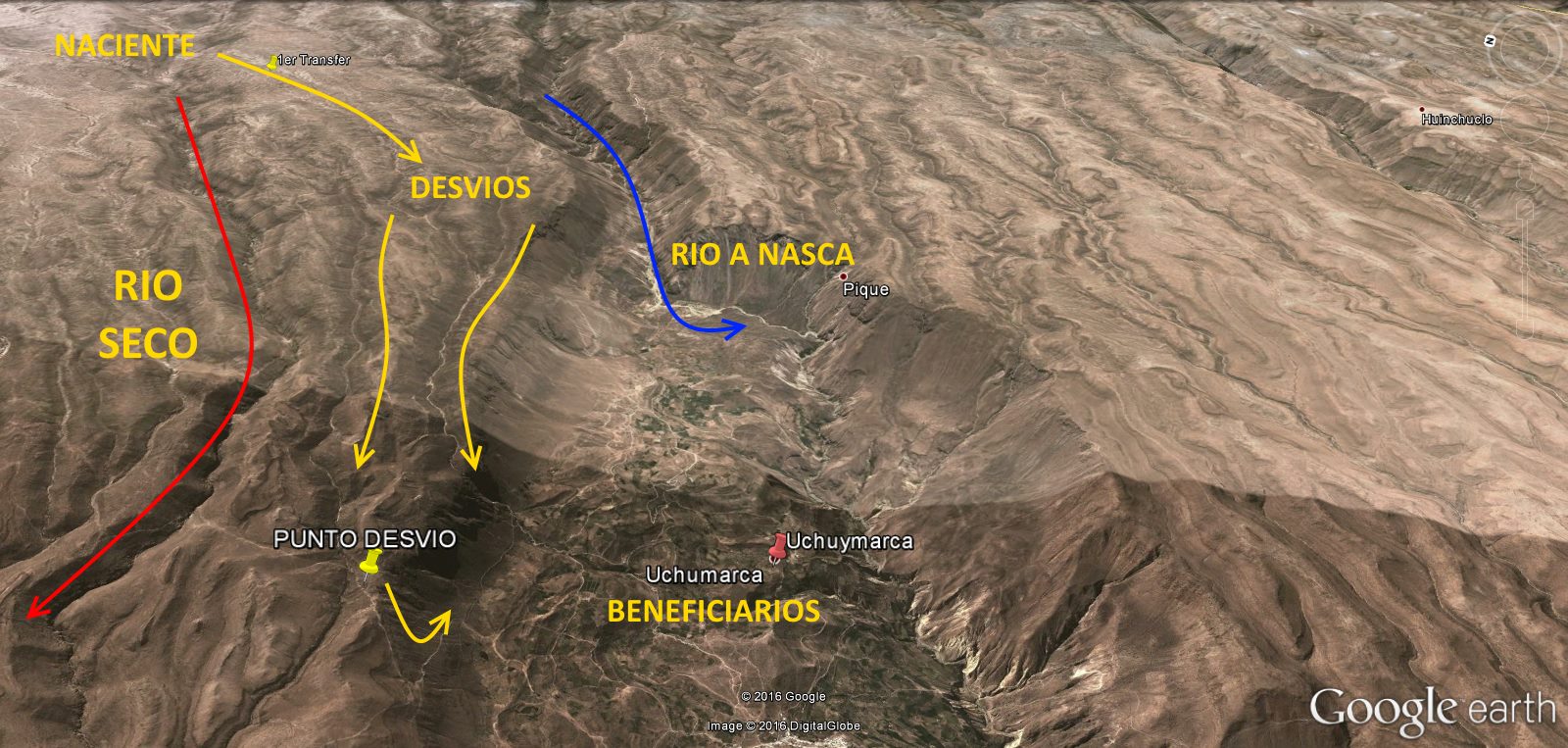
There is a high probability that the Nasca culture has run out of water for mechanical reasons. Simply the neighboring civilization, in the heights of Nasca, used the water diverting it from its original source to its farms and andean platforms in the mountains. This story goes back more than 2,500 years, when whoever control de water in the highlands, control agricultural survival. A culture that enjoyed the vital liquid, was gradually stripped out of water until there was no other option but to migrate to areas where water still exists today.
Large reservoirs of water in the heights, controlled manualy, to endure and care for the God WATER. The NASCAS controlled in their time, HUAICOS (floods) without much effort, naturally using gravity, where it possible its handling.
The great thing about my research is that I notice in the centuries of work lines as a trial and error, with more successes than failures. The failures were due to terrain factors, sometimes with failure. Success were by the wisdom of the engineers who, without topographic tools or heavy machinery, channeled as best they could the liquid, base of the agricultural organization of this culture.
UNDERSTANDING THE CODE ... AND OVNIS (UFOs) ran out of LANDING TRACKS:
DEMO 3D: http://www.youtube.com/
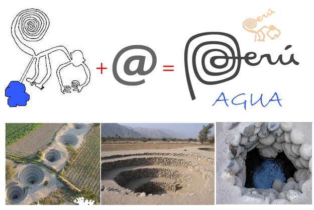
"Gutters (in blue) are found by joining the Water Collection Polygons (in red) as well as extensions of the Decanters (ligh blue), the purpose was to transport the liquid captured by the Polygon. Coils (in green) are on the Polygons (in red) can be used to control the fluid fluid captured by the Polygon. Note the Geoglyph "The Spiral" (in yellow) found in several parts of these substructures making possible its location and naming of the structures."
The lines were simply the mechanism of distributing the liquid in the extensive pampa to transport water between the basins. The great thing is the simple management of gravity by mass of water acomplished by the channels. The marvelous way was the control of said liquid using simple Locks (and Dams) in NASCA. Great contribution of the hydraulic engineering used throughout the Inca Empire (Andes or Empire of andean Platforms) at a later time
The errors in the pampas exist, it was a matter of trial and error, (That´s why many lines are view by satellite). The hard work of the engineers to calculate the angles of inclination through which the liquid would flow, it is amazing. We are talking about several meters of elevation up to less than one meter of inclination for several kilometers in length, made manually, where only with satellite instruments that I can now check the basis of my research. (Thanks to Google Earth) I strongly believe that the Andenes, and almost all the hydraulic engineering deployed in Nasca, was the primary tool for understanding the wonders of the inca marvelous water handling.
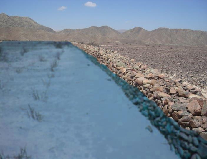
DAMS and LOCKS IN NASCA? IF THERE ARE, thenTHERE IS WATER. This is the discovery of water management locks. A whole system in the heights that handled the liquid towards the famous lines in the pampas.
Nasca kept this network hydraulically connected for hundreds of years, to the point of breakage, where water could no longer be transported over great distances physically (mass by gravity), with all the floods and water problems, the liquid, inevitably stop flowing between the basins.
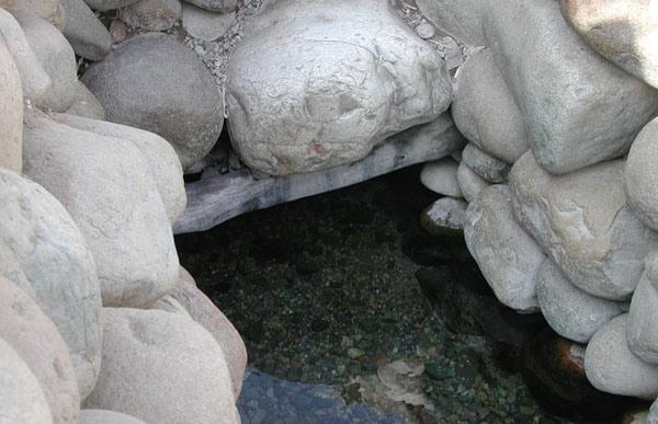
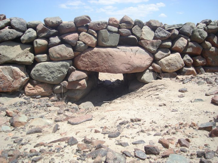
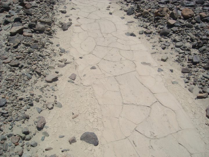
A frame made of Huarango (means one thousand in native language) wood, supports for more than 1000 years the structure and underground channel Nasca in Cantayoc. Only an ancient wood makes that structure does not collapse. Most importantly, WATER REMAINS FLOWING without interruption. PHOTO:http://hidraulicainca.com/
It is not a defeat, on the contrary, our engineers left us and demonstrated indescribable capacity, it is an engineering feat, newly decoded and interpreted. So I can demonstrate and learn, with this book, with mathematical precision, the progress of our ancient countrymen. I say it this way because there is no other way to describe it. I am not an archaeologist, I am just a humble Peruvian citizen computer scientist, a descendant of these people, who reveres our best engineers. As I will always say, "We must not complain, we descend from the best, we now have to emulate them".
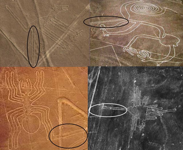
Why do they have an extra leg or what does that extra line mean in geoglyphs?
The giant figures were divine, and they are connected to the lines or channels in the Nasca pampas with that extra connection ... My hypothesis: These, as the water passed through the channels got wet ... Where there is humidity because there is another coloration , and of course weeds and green weeds grow ... I imagine green or moisture colored geoglyphs where over long distances I could monitor or verify the functioning of the channel where it is connected only by the level of humidity in each geoglyph ... These animals It is not that they have another limb but it is their connection to the hydraulic system. COULD YOU TELL ME, IS THE DOG OR THE MONKEY WATERING THE LAND, due to our PRAYING and BLESSING THE EARTH? I leave this open for scholars of Nasca mythology, but I figure that Nasca pray those gods and in return, they allow water to their dry land.
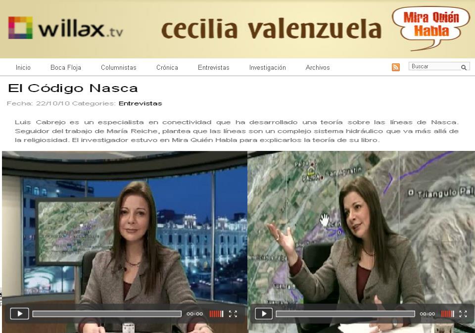
CECILIA VALENZUELA, WILLAX TV (Minuto 11:06)
PARTE1 http://www.youtube.com/
PARTE2 http://www.youtube.com/
"Why not listen, when someone has a really innovative idea. I am pleasantly and impressed by what the author has revealed to us in his work, and we will wait for the authorities that have to do with engineering, culture, the environment, development, agriculture and water in our country, pay close attention to this book and theory of THE NASCA CODE, A LOT OF LUCK IN THIS GREAT ADVENTURE YOU HAVE STARTED " Willax Televisión —
There should be an interdisciplinary council, dedicated to studying these issues. Private or government institutions separately do not have the right personnel to be able to decode the many puzzles to be solved, such as Inca writing, quipus, ceques, connectivity, imperial mathematics, among others. I have used many factors to solve Nasca, and the work information of many archaeologists has helped me to route along the correct path of geometry and hydroconnected networks. I must not assume that the Archaeologists have knowledge of networks and Inca connectivity to solve these problems, since it is not their specialization, but it is necessary to study together the archaeological remains to decipher in “group of intellectuals” so that the “imaginative brainstorming” has more chance to solve any enigmatic problem, such as this one in Nasca.

VERÓNICA AYLLON - ATV: CANAL 9 PROGRAMA "DE PELICULA" "Today a new hypothesis arises around the Nasca Lines, where Luis Cabrejo indicates in his theory that the lines would be nothing more or nothing less than a huge irrigation system ... Source: http://www.youtube.com/
In conclusion, it is my contribution, it is possible that I have decoded our Nasca engineers and their networks, I feel a little late and slow, but I have the “Pleasure of having had the honor of having understood my colleagues, which is why, I am honored to be a colleague who transmits the progress of our Andean Engineering to all of Peru and the World ”

LIVE - Radio CAPITAL LIMA, AUDIO ... Here the complete program "TRIP TO ANOTHER DIMENSION" theme "THE NASCA CODE" http://www.youtube.com/

Dialogue with colleagues of the CIP - College of Engineers of Peru on Andean hydraulic issues.
From: EL COMERCIO (MIGUEL VIVANCO USA)
Subject: ENTREVISTA
Date: Mon, 5 Apr 2010 14:51:37 +0000
INTERVIEW IN WASHINGTON DC
MV - In simple words, what was Nasca?
LC - Nasca was a huge high precision instrument, to transport water between several "Almost impossible" irrigation basins, with its ceremonies of gratitude as a plea for the liquid element. This complex worked in a different climate, there had to be humidity, where large pools accumulated water and redistributed it through channels using only gravity and some other control structures.
"We have a problem that represents our advantage, we have the blueprints to solve it. Our ancestors have 50 centuries of advantage, which if we revalue the ancestral knowledge, automatically everything adds up in our favor ". And after 2000 years, history repeats itself. Its a cycle. Simply, Nasca surpassed its contemporaries for centuries even now. You controlled the waters, huaicos (El Niño) and you control everthing. We are studing this technology in depth today, government is competely ignorant about this issues.
MV - What about the giant figures, like the monkey, the spider?
LC - That is Nasca divine cosmic symbology, their gods. But they had meaning and do the some work. The figures are linked to a certain group of structures, such as canals, pools, dams and locks. This group of structures has been maintained by groups of beneficiary families who were in charge of its operation. This work was physical, they did maintenance over the channels, when channels where transporting water, that is to say, it carried water, these figures got wet and changed color and probably got vegetation growing around them. (Imagine those huge figures green, you could see them from miles away) it was a method of "monitoring" the operation of the structure in question. If their "god" was not wet then they proceeded to make offerings and even sacrifices because they had not been "listened or favored" by gods.
Why do they have an extra leg or what does that extra line mean in geoglyphs? The giant figures were divine, and they are connected to the lines or channels in the Nasca pampas with that extra connection. My hypothesis: These, as the water passed through the channels got wet ... Where there is humidity because there is another coloration due to plants growing there, and of course weeds and green weeds grow locally. I imagine the geoglyphs green or colored by humidity where at long distances you could easy monitor or verify the operation of the channel where it is connected only by the level of humidity in each geoglyph. These shapes are have another limb and is their connection to the hydraulic system. COULD YOU SAY, IS THE DOG OR THE MONKEY PEEING (FECUNDING) OR BLESSING THE EARTH? I leave this open for scholars of Nasca mythology to start thinking about my thesis
MV - How does that infrastructure worked?
LC - Well, as it was a natural system, it used gravity only and some control systems. For this they had to use the heights to gain potential energy (water by gravity) Then from the heights the process began. Then with a complex system of dams and locks, they redirected water to the infrastructures that required. We are talking about a precision system, where water can be derived over long distances using only the slope originally from the hills or plateaus (in Palpa) and then down to the valleys down in the Pampas in which there is a minimum slope of a few meters for every km in length.
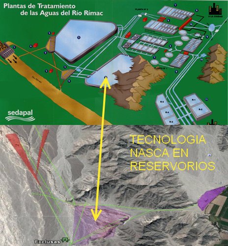
It similar to what we use now, after centuries, the Nasca were precursors of technology similar to the one currently used by SEDAPAL our water management system. ITS FANTASTIC; THEY HAVE THE SAME ELEMENTS AS IN THE NASCA PAMPAS 2000 years ago... Source: http://www.sedapal.com.pe/
MV - What happened finally, why did it stop working?
LC - Some possibilities, which can still be speculated, is a climatic change that happened gradually, where several tributaries simply dried up and only the channels remained without water flow. Now, why the weather changed, is a matter of study even now in our days. It is not a new problem, but is a current problem. A second version is that the WARI, a neighboring local group and a possible enemy, practically closed the flow at heights gradually, which cannot be ruled out because it was the Wari who took control of the lands in question by war.
Years 535-536 were the most serious and prolonged short-term refrigeration episodes in the northern hemisphere in the last 2000 years. That would mean terrible droughts and famine in the southern hemisphere. Details: http://es.wikipedia.org/
MV - Why the Title of your Work: The Nasca Code?
LC - This problem is not a new issue as I mentioned before, in this book that I have called "The Nasca Code", is because I understand that it can be the key to the management of this natural water resource at very delicate levels and with the necessary precision required currently due to the climatic changes that afflict us. It is a lesson on how to make use of ancient technology to overcome a current problem that can be used even in other parts of the world to control floods and droughts.
Water misuse is another problem. Of the 500 million m3 demanded by city of Arequipa, more than 200 are wasted. Agro in the province, which currently has 47 thousand hectares (ha) under irrigation, is the sector that reports the most problems, and is that it wastes 65% of the resource due to the poor culture of irrigation.Fuente - Source http://www.larepublica.pe/
MV - Why did you study the complex?
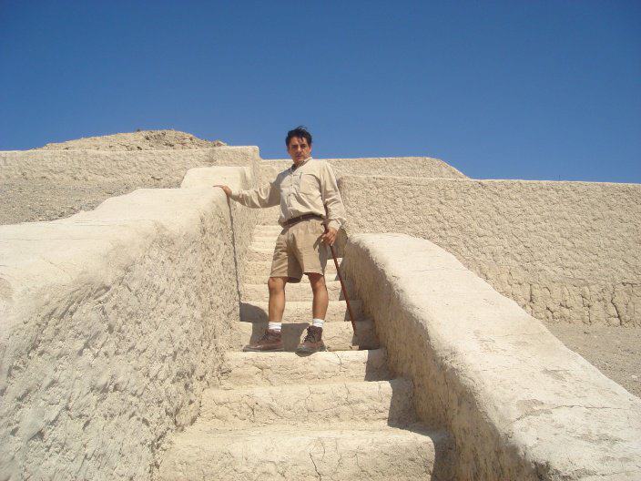
LC - Always looking for reasons. Well, when I visited ICA (Nasca) in 2003, and I went to do a study on the use of antennas in some of the mountains, there are Inca and Pre-Inca arqueological remains still in the heights, things that have not been studied. But in Nasca, I could see something even more surprising, I observed "huge line of sights", this is physical lines in the pampas and hills. The first thing I remembered was Maria Reiche, and I tried to see the functionality of these lines. The Lines exceed the curvature of the earth in what line of sight is about (approximately 30km) which are simply surprising. Then I tried to give them an astral meaning, but it did not match the anthropological issue. The current and regular problem is lack of water, so I began to investigate previous studies and found that it had already been suggested in the 40's before Reiche, that these could have been linked to the hydraulic issue and I focus on that. Then my vectors squared perfectly. I went to Nasca to certify at the heights the "start and end" of these vectors and I was able to discover the dams and locks, and other water collection structures.
Mr José Matos Mar (QEPD) Peruvian anthropologist "Gran Amauta" (Great Teacher) and a colleague at the National Council of Decentralization CND in the PCM where I worked, was the one who encouraged me to "climb" and visit the heights of Nasca. He asked me to take pictures of the structures I could find in the field visits. When he came back to the office and showed him the photos, his first question was "Let's see the photos" after I showed them, he inmediately yelled "WONDERFUL, then water is the key". Thanks to him and his "desire to know and understand" is how we completed the Nasca puzzle. I proposed to take him to the heights of Ica, but he said to me "What you are going to see there, you must write it for future generations." I dedicate my work to my great friend whom I recognize, propose and accept the honorary position of "Director the book", a recognition in life to a great Ayacucho greatest mind, writer who understood these issues and many more.
"WHAT WOULD SAY IF AUTHORITIES AND THE PRESIDENT ANNOUNCES THAT ALL THE PERUVIAN ANCIENT HIDRAULIC WONDERS ARE REACTIVATED, OUR SLEEPING HERITAGE, INCLUDING ALL THE ANDEAN HYDRAULIC INFRASTRUCTURES ARE REACTIVATED TO BENEFIT HUMANITY? " LC
MV - What finally made you launch your work?
LC - A few weeks ago, while I was finishing out my theory, almost in parallel, NatGeo (National Geografic) publish a documentary called "DECODING THE NASCA LINES", I thought they had already solved the problem, and I was sad because I thought they nailed it and I was late to announce it. But they only confirmed ceremonial sacrifices of the Nasca culture about water. Very important thing, because with that I closed the circle. But as its title mentions, and at the end of the program, they did not finish decoding the real issue, since they only talked about archeological facts and did not mention how Nasca Lines worked. That's why I immediately went to a local museum and shared my theory with the curators, who they told me that I was very close to the anthropological and archeological issue in order to support the engineering part. They suggested that I read more in depth the works of 1940 which at first impression were correct, and to write my findings inmediately.
PROPOSAL: TO REACTIVATE 1 MILLION HECTARES OF FORGOTTEN ANDENES, THIS WITH FULL CONNECTIVITY, WITH INTERNET FROM MOUNTAIN TO MOUNTAIN , MONITORING AND REMOTELY CONTROLLING THE LEVELS OF WATER, PRESSURE, MOISTURE, TEMPERATURE, SO THAT FROM A WEB PAGE, WE KNOW THAT IT IS HAPPENING EACH PLACE, INCLUSIVE WITH CCTV CAMERAS AND REMOTE CONTROL SYSTEMS. IT IS WHAT WE NEED TO BE FULLY INCLUDED ... ALL ON THE INTERNET, THE INCA NETWORK AND THE APUS (Sacred Mountains) INTERCONECTED.
MV - Do you think the complex is in danger?
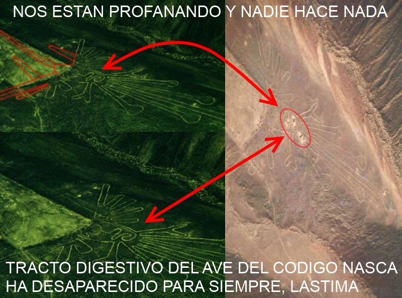
LC - Yes, As I always said, since 2005 in the first reports, the public enemy of the lines and everything archaeological in Peru, we are ourselves. It is not only these ignorant people that are damaging the structures, that due to ignorance (no excuse) but also current planning does not help. Cities invading, currently bordering and literally developing on top of the structures. Even the Pan-American road its over the lines of Nasca making it easy available to walk without control damaging the lines.
Given the apparent passivity of the regional and local authorities of Ica, dozens of invaders have illegally occupied spaces in important archeological areas of the provinces of Nasca and Palpa. The situation is very worrying, because they are damaging, as if nothing happened, geoglyphs and pre-Inca lines considered Cultural Heritage of the Nation. FUENTE SOURCE: EL COMERCIO :http://elcomercio.pe/peru/
MV - PAN-AMERICANA south road?
LC - That's right, it was a line before. They saw a line so straight that they assumed it was a trail and traced over that route what is now the Pan-American South, Palpa - Ica section. It crosses over several Geoglyphs, which are now partially damaged.
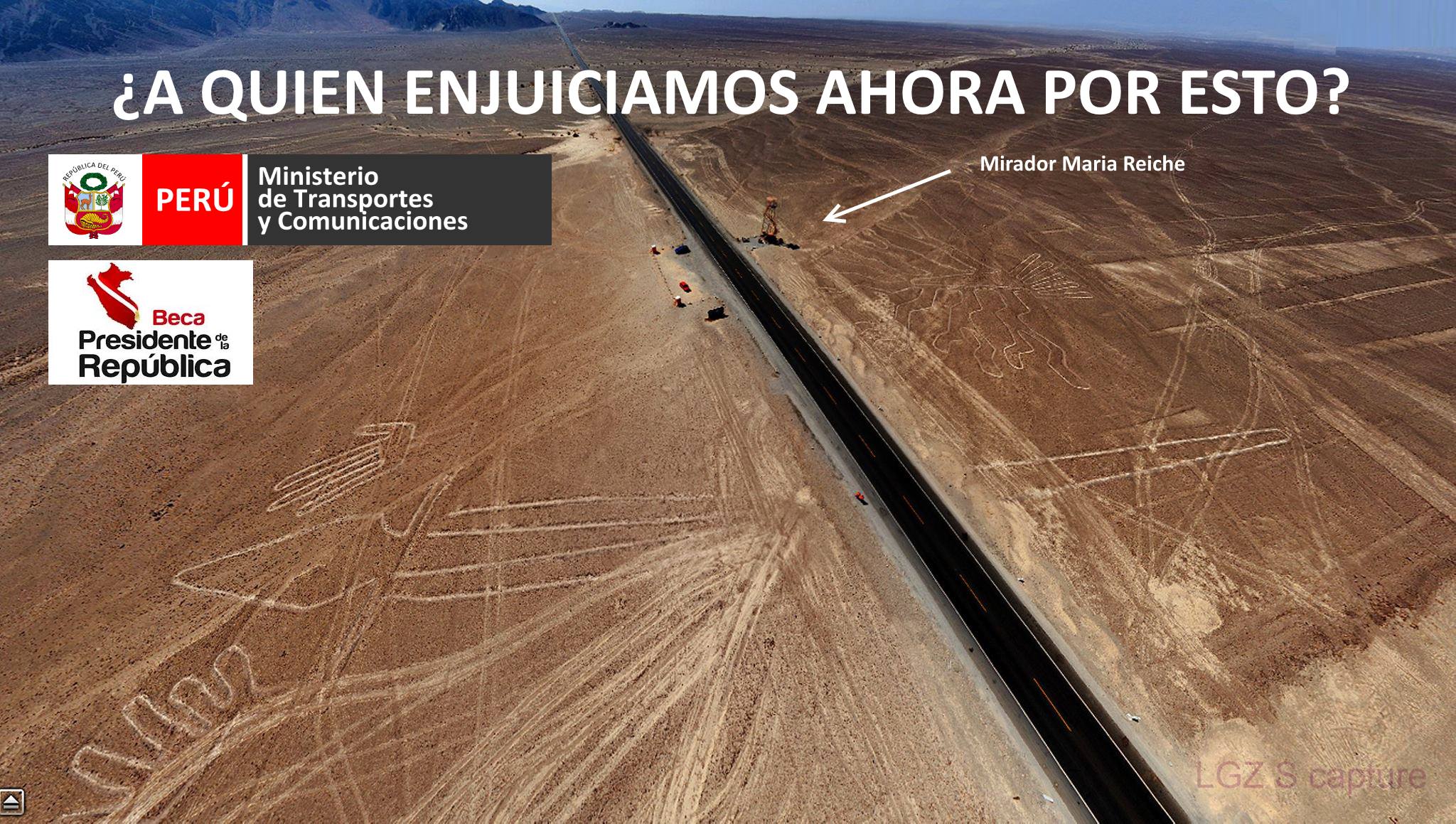
THE PAN AMERICAN HIGHWAY HAS DESTROYED A GREAT DEAL OF LINES OVER NASCA
MV - What do you suggest to do about this?
LC - Protect them inmediately. What would you do with tremendous archeological achievement? I compare this feat only, with the wonders of the "Hanging Gardens of Babylon" or with the "Aqueducts of Rome." It is definitely an achievement “Wonder of the World” archaeological style of hydraulic engineering, the basis of many achievements of the Inca Empire. Recall that the Nasca were a Pre-Inca culture, which may have left this technology as the basis of agricultural engineering for our empire based on "Platforms." (The Andes, or place with Andenes) Do you think SOMEONE would let these archaeological remains touch, in other countries? Maria Reiche was correct in caring for future generations. Now you have to study them in depth, since they may contain the key to how to handle our geography to near perfection.
MV - What do you expect from this?
LC - I EXPECT TO LEARN: Honestly, I just intrigued myself with this enigmatic problem and it seems to me that I solved it. They underestimate us by saying that it was the UFOs who made tremendous engineering works, or that we tried to communicate with them via the geoglyphs (which could have a religious connotation without a doubt but for an elementary purpose that was the irrigation of the farms, that is to say survive) I hope they stop being stupid and respect our ancestors, great engineers who knew how to handle in detail an issue that is still a problem today. This is not a new or old issue, is an actual problem, with global warming and all that stuff. But with this we confirm that disasters are something that happened, are happening and will happen always. The imagination only limits us to overcome them, and each one has its variables to solve them. In our Andean case, named for the hydraulic wonders of the Andenes, they are the geography control key which, in my opinion, was learned at NASCA, and its structures.
MV - I see that you have outlined other theories about Nasca?
LC - Indeed, in 2003 I read Reiche's work, it is partially correct, because some primary lines align with the cosmos and glyphs may be constellations since they represented natural divinities. Then with the many earthquakes, I joined in 2006 and with that of Pisco and now in Chile, when they showed that the earth was changing shape. (Tectonic Plates) then it is totally feasible to measure the "Drift Angles" between the American and Nasca plates in ration to those stars. There is a deviation, they no longer agree perfectly due to the problem of pressure, which is a phenomenon of the earth that varies in polar angle. They were good theories, but they do not carry the anthropological significance of real subsistence.
LUIS H CABREJO